Nossos Serviços

Tecnologia e inteligência para o agronegócio em Iturama e Triângulo Mineiro.

Drone flying over a lush green agricultural field capturing data for precision farming.
Detailed agricultural map showing variability zones and crop health indicators.
Mapeamento

Mapeamento agrícola detalhado para identificar variabilidade e planejar melhor as áreas.
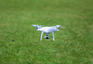
Pulverização

Aplicações via drones, precisas e seguras, especialmente em áreas de difícil acesso.

MAPEAMENTO

Mapeamento agrícola detalhado para melhor gestão.

Aerial view of farmland with digital overlay showing crop variability maps.
Pulverização Drone

Aplicações precisas e seguras com drones, especialmente em áreas de difícil acesso, otimizando o uso de insumos e aumentando a eficiência.

Drone spraying crops over a green field during sunrise.
Análise Dados

Transformamos dados agrícolas em informações estratégicas para decisões que aumentam produtividade e reduzem custos no campo.

GALERIA

A drone flying over a lush green agricultural field capturing high-resolution data.
Close-up of a detailed agricultural map showing variability zones in a farm.
Technician analyzing crop data on a tablet with fields in the background.
Drone spraying crops with precision in a difficult-to-access area.
Graphs and charts displaying productivity and crop health data on a computer screen.
Wide aerial view of a large farmland with visible crop patterns and green zones.

Tecnologia e inovação no campo em imagens